Active tourism
Put yourself to the test in an unparalleled natural environment
Active tourism
Put yourself to the test in an unparalleled natural environment
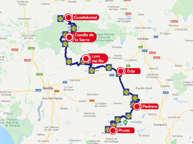
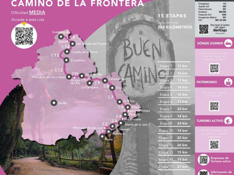
The Sierra Sur de Sevilla has been considered a natural frontier since the late Middle Ages, defined by the mountain range itself and a military border of bastions and fortified towers scattered along this southern mountain range. The first stretches of this stage of the Camino de Santiago are somewhat demanding, although they are blessed with outstanding scenic beauty.
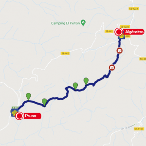
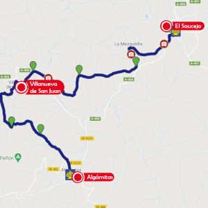
The hardy traveller will take the Olvera to Pruna track past the Álamo hill and the Caracola fountain (701 m.) as far as Pruna. Here, you continue along the road to the chapel of the Virgen de Fátima next to the Arroyo de las Mujeres (Women's Stream) and at the foot of the imposing Tablón mountain range, topped by the peak of El Terril (1,128 m), the highest peak in the province of Seville. The next tough section is the Zamorano pass (777 m) with spectacular views of El Peñón de Algámitas (1,121 m) and the far side of El Terril. You follow the streams of Ballesteros and El Membrillar as you leave Algámitas in the direction of Villanueva de San Juan next to the River Corbones and the Alto hill (642 m). In the vicinity of the Raya mill, you cross the meandering river Corbones over the Puente de los Seis Ojos (Six-Eye Bridge) while enjoying the riverside woodland. The Camino de Santiago climbs towards the hills of Andújar (552 m.) and La Goína (553 m.). From here, you continue towards El Saucejo next to the Canteras hillock (615 m).
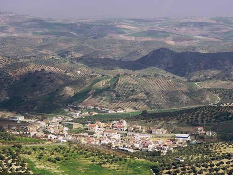
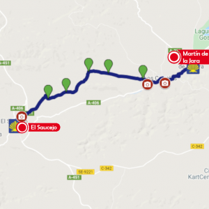
The initial steep hills of the southern highlands now give way to medium-sized hills and mountains where the natural species of the Mediterranean forest continue to predominate. At the old Roman Irni you take the path to the Porqueras spring and the hills of Rosco (567 m.) and Pedro Benítez (592 m.). You continue along the Almadenes track between the Cañada Estepilla stream and the Almadenes mountain range (587 m.) as far as Los Corrales. The Fuente del Esparto stream is the main tributary that crosses the municipality of Los Corrales, and the nature reserve of the Gosque lagoon is the most important natural resource in the municipality of Jareño. The landscape of olive groves becomes more pronounced as the hills and ridges become gentler. Even so, the walk continues through the rugged mountain ranges at a certain altitude throughout the region of Estepa
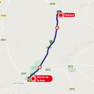
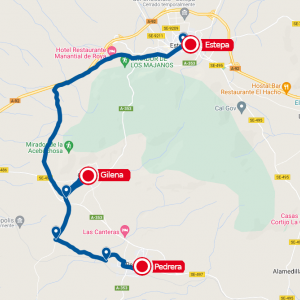
In Martín de la Jara you walk passing close to the protected lake. Further on you cross the streams of Carnerero and Salado de Pedrera next to the hill until you reach the town of Pedrera.
Is in Estepa where the Camino de Santiago border route meets the Camino de Santiago Antequera route.
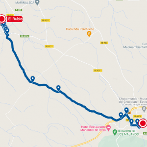
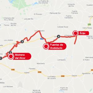
This ancient, heritage village is the watchtower, guardian and custodian of a sea of olive groves whose 'liquid gold' (oil) has been the pride of the region for thousands of years. You leave the Sierra de Estepa behind you and follow in the direction of the River Blanco as it passes through the town of El Rubio.
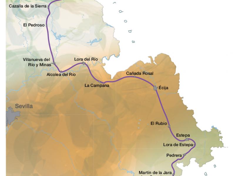
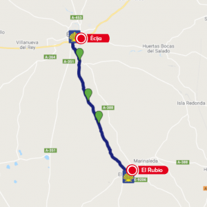
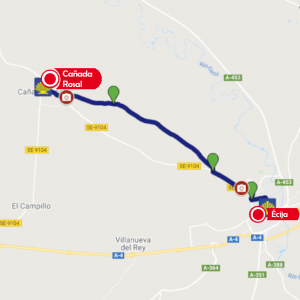
In El Rubio you walk downstream along the River Blanco, passing by the Calatrava hill and coming to the road to Ecija. On this immense, gently rolling plain you pass the farmhouses of Salado, Gallape and La Higuera, cross the Tomillar stream and continue through the Ecija estates of Los Arrieros and Las Monjas until you reach the confluence of the Blanco and Benavides streams at the River Genil on the outskirts of the town of Las Torres. From here you follow the path of Las Dehesas (El Gobierno and Los Ramos) along the stream and past the Cucarrón farmhouse, and El Telégrafo as far as Cañada Rosal. You leave the 18th-century town through the house of El Candil towards Los Abantos, passing by the La Picadilla farmhouse, crossing the Madre de Fuentes stream, arriving at the Jadraque estate and crossing the Cañada Real (Royal Cattle Track) of Palma del Marqués.
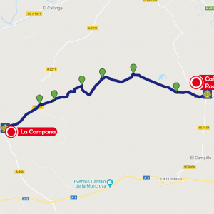
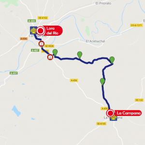
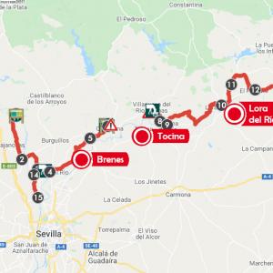
Continue walking past the hamlet of La Aldea and the Panadero lagoon until you come to the Cerrados farmhouse, where you cross the Mayo, Cercados and Anea streams before reaching Los Huertos on the outskirts of La Campana. The border route leaves the cereal and cotton fields and gives way to the greenery of the fertile Baetic plain. You then enter the moist, fertile lands of our Rio Grande, the ancient breadbasket of the province. In the town of La Campana, you walk beside the Lora del Río road past the Casilla El Palo, cross the Gamonal stream, and pass by the Zahariche, el Palo, El Pastor, De Felipe, and Del Puerto farmhouses.
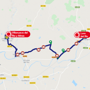
Continue along the Guadalora stream, cross the Lower Guadalquivir canal and the Rio Grande at the Casilla de la Barca until you reach Lora del Río. You leave here along the Alcolea path, crossing the Tostado, Algarín, Las Torecillas and Tamujo streams. On the way you will come across La Florida and the ruins of Arva before reaching Alcolea del Río. Follow the Guadalquivir downstream in the direction of El Ventorrillo and cross the Galapagar stream to reach the village of Villanueva del Río y Minas.
After the fertile riverside plain and its market gardens, you enter the Sierra Norte de Sevilla Natural Park. Its characteristic hilly landscape consists of dehesas, holm oak, cork oak, Potuguese oak and chestnut woodland, and gallery forests (ash and willows).
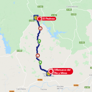
In the mining town, you cross the River Huéznar at the Guadalquivir farmhouse towards the El Pedroso track. You pass the Las Arenillas halt, the ruins of the Ventas Quemadas halt, the house of La Mina and the Puerto del Cid farmhouse until finally reaching the Villanueva track.
You continue walking in the proximity of the house of Romero and the impressive Huéznar reservoir. You cross the Acebuchal path and come to Cerrado de Lora, where you cross the Navalfresno del Corchuelo stream, passing by the house and pyrite mines of Navalázaro and El Redondillo until you reach the old town of El Pedroso.
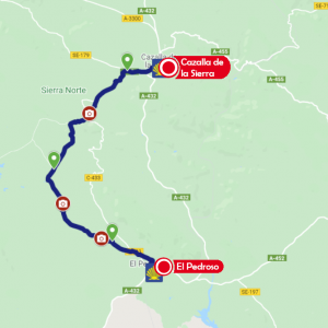
After the town of Pedroso, along the side of the A-432 road, you come to the Castrejón farmhouse next to the Huéznar reservoir. You continue north past the Molino del Castaño and La Fábrica (Chestnut Mill and Factory), crossing the San Pedro stream towards the Los Cardales and Trasierra farmhouses, passing the Vega stream and arriving at the picturesque village of Cazalla de la Sierra. From this mountain village you take the path of the A-455 road past the house and stream of La Garganta, passing through the farmsteads of Nuestra Señora del Carmen and Los Ángeles, and arriving at Cazalla station. From here you cross the River Huéznar, following the stream and taking the shortcut to the SE-168 road.
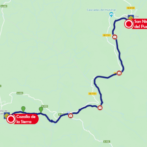
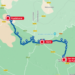
Continue past the house of the Foundry, and the farmhouses of La Paloma, Las Moreras and Batán Onofre, to finally come to the Nuestra Señora del Carmen power station and reach San Nicolás del Puerto. In the village of Marucha, after crossing the Huéznar again, you head for the Los Molinos path, passing the houses of Don Juan Bajo and Don Juan Alto, and skirting the Fontanar hill via El Llano to Alanís. The path along the A-432 road from Alanís takes you to the Los Barriales Altos farmhouse and the house of La Chistera, crossing the Esteban Yáñez track and the Benalija stream, passing the Los Remedios farmhouse, the houses of La Legua and Cuatro Genales, the Los Prados farmhouse and Villa Susana. This mountainous section runs between the hills of Hamapega (909 m.) and Amoladera (811 m.), and the Sierra del Agua (813 m.).
Continue along the San Pedro stream, past the chapel of San Benito and the Escutia hill as far as Guadalcanal. The intrepid traveller will continue along the path of Los Molinos and the Sierra del Viento (921 m) towards the lands of Extremadura.
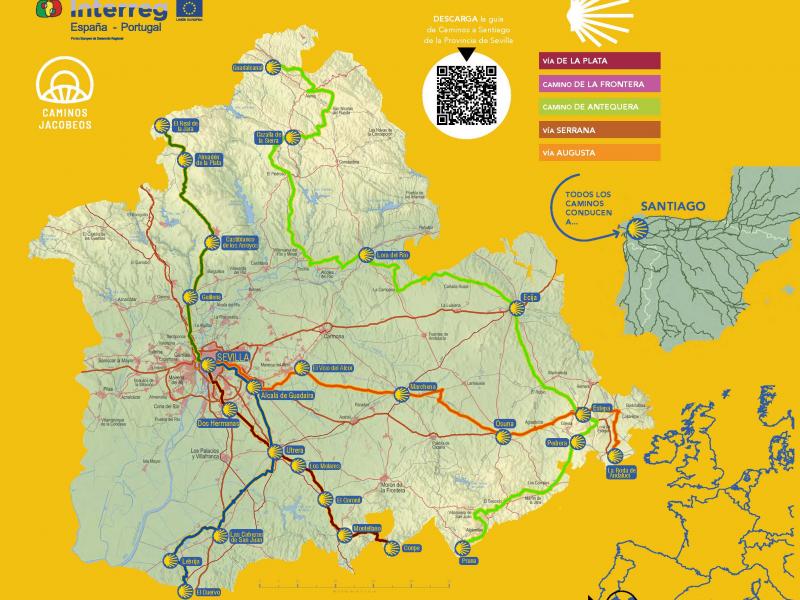
The Santiago Commandery of Guadalcanal marks the end of Sevillian section of the Border Route of the Camino de Santiago, which now enters the neighbouring Campiña Sur in the province of Badajoz as far as Almendralejo, connecting with the Vía de la Plata (Silver Route) Camino de Santiago.
0 comments
New comment
The comments are moderated, so it takes a while to appear. If they contain offensive language they will not be published.